Antarctica's Pine Island Glacier holds a dubious honor—it is currently the largest Antarctic contributor to global sea-level rise, thanks to the enormous amount of ice it has lost in recent decades. Now scientists have identified the likely cause of some of the glacier's most spectacular calving events, which have birthed icebergs several times the size of Manhattan.
The culprit: submerged rock ridges that poke up high enough to occasionally hit the bottom of the glacier. This activity creates small cracks that grow and eventually cause massive chunks of ice to break off. But the undersea rocks are not all bad news—they can also help stabilize the glacier by grinding against its underside, buttressing it against flowing faster out to sea.
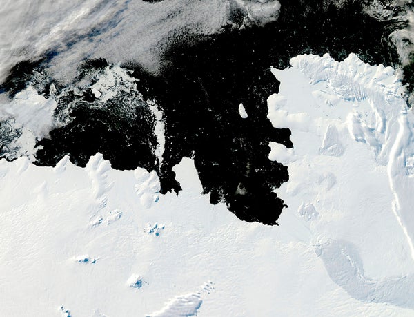
Jan Erik Arndt, a geophysicist at the Alfred Wegener Institute Helmholtz Center for Polar and Marine Research in Germany, and his colleagues departed Punta Arenas, Chile, in February 2017 onboard the icebreaker Polarstern. A week or so later they arrived in Pine Island Bay, an inlet filled with icebergs and dominated by the glacier's 40-meter-high face. They were there to figure out what controlled the stability of this expanse of ice.
On supporting science journalism
If you're enjoying this article, consider supporting our award-winning journalism by subscribing. By purchasing a subscription you are helping to ensure the future of impactful stories about the discoveries and ideas shaping our world today.
Arndt and his colleagues launched sound waves from the Polarstern's hull into the near-freezing water. By measuring how long it took the waves to bounce off the seafloor and return to the ship, the team mapped hundreds of square kilometers of the bay's underwater topography. The researchers focused on an area exposed by the glacier's recent calving—a swath of seafloor that used to lie below about 400 meters of ice. “It was a good opportunity to go in there and map this area that was not accessible before,” Arndt says.
He and his team discovered a complex undersea landscape. One feature literally stood out—a rocky outcropping that, at its tallest point, reached within 375 meters of the surface. “We were surprised to see this huge ridge,” Arndt says. This rock, the team realized, had very likely pushed against the bottom of Pine Island Glacier in the past. The giveaway was a bump on the glacier's surface—glaciologists call it a “rumple”—directly above the location of the ridge in archival satellite images. “We saw the surface imprint of the topography underneath on the ice shelf,” Arndt explains. As the ice pressed against the ridge, it probably also acted as a brake, preventing the glacier from flowing unimpeded into the ocean, the researchers hypothesize. They suspect it had been effectively pinned that way since the 1940s.
But the brake eventually failed; Pine Island Glacier probably lost contact with the ridge in 2006, after a warmer current of water eroded the glacier's underside. That is when the rumple disappeared in satellite images, the team reported in June in the Cryosphere. (Scientists say a volcano under the glacier, discovered earlier this year, most likely contributes to its thinning as well.) As Pine Island Glacier once again slid toward the sea, it probably hit other submerged rock features the Polarstern's mapping identified, the researchers say. Those collisions stressed the ice, creating kilometer-long rifts spotted in images taken in 2007 and 2011. These rifts then grew, finally spawning giant icebergs.
Seafloor features are “really important” to an ice shelf's stability, says Richard Alley, a geoscientist at Pennsylvania State University, who was not involved in the research. This study is “addressing an interesting question in a fascinating place,” Alley says. Jeremy Bassis, a glaciologist at the University of Michigan, adds: “The troughs and bumps in the bottom of the ocean beneath the ice play a huge role in regulating when the ice will break.”
As glaciers flow into the sea and melt, sea levels rise. That is bad news for a large chunk of the world's population; roughly 40 percent of all people live within 100 kilometers of a coastline. Some U.S. cities, such as New Orleans, already lie below sea level. Others, including Miami, currently experience regular flooding.
For now, Pine Island Glacier is stable—its northern section is pinned by a small hill on land, and its southern front is corralled by a thick stream of ice. But change is on the way, Arndt and his colleagues predict. Late last year they spotted a 30-kilometer-long rift in the glacier—the likely site of its next calving event.