Videos circulating on social media show an 18-foot wall of water advancing on the horizon.
The tremendous wave builds to a crescendo when it barrels ashore, submerging buildings already toppled by the deadly magnitude 7.5 earthquake that pummeled the northern part of Indonesia’s Sulawesi island last weekend (and triggered the inundation). The temblor and tsunami have killed well over a thousand people, with the toll expected to rise. The tsunami surprised the local population and, at first, some geologists, because the fault that ruptured was not the type typically associated with tsunamis.
Most big tsunamis, like the series of waves up to 100 feet high that killed more than 200,000 people around the Indian Ocean Basin in 2004, result from a sudden lurch of a subduction zone —a line where one of Earth’s tectonic plates is slowly diving beneath another. This heaving of the seafloor forces ocean water upward and outward. The tsunami that recently devastated the city of Palu on Sulawesi, however, was associated with a “strike-slip” fault, where two plates are sliding past each other. “It’s not something that you would’ve predicted,” says Jim Gaherty, a seismologist at Columbia University’s Lamont–Doherty Earth Observatory.
On supporting science journalism
If you're enjoying this article, consider supporting our award-winning journalism by subscribing. By purchasing a subscription you are helping to ensure the future of impactful stories about the discoveries and ideas shaping our world today.
But strike-slip faults can also generate tsunamis through a couple different mechanisms that geologists have been evaluating for this event, in real time on Twitter and other social media platforms. The event, they say, speaks to the complex tectonic jumble that lies beneath Indonesia’s 14,000-plus islands.
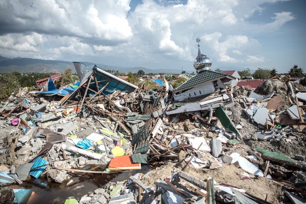
Aerial photos of #tsunami and #earthquake damage in #Palu have been released by #Indonesia's disaster management agency @BNPB_Indonesia pic.twitter.com/VRUecgJnH0
— Richard Woods (@RichardWoodsNZ) September 29, 2018
Underwater Landslides
The earthquake’s shaking may have loosened sediment on a slope below the sea’s surface, triggering a submarine landslide that pushed water out of the way and sent it rocketing toward shore. Such occurrences have long been known to cause massive tsunamis; a rockslide triggered by a magnitude 7.8 earthquake set off the mega-tsunami in Lituya Bay, Alaska, in 1958. It sent water roaring up mountainsides to reach elevations of 1,700 feet, and remains the largest tsunami recorded in modern times.
Another possibility is the movement of the fault itself caused the tsunami. Although the fault moved horizontally and not vertically, the steep slopes and other unique features on the floor of Palu Bay could have pushed water in front of them as they moved during the earthquake. “It’s like pushing your hand through a bathtub,” says Chris Rowan, a geologist at Kent State University. Researchers at the Karlsruhe Institute of Technology in Germany have done a preliminary study with a tsunami model, and found the lateral movement of the fault and the topography of the bay would be enough to generate a tsunami the size of the one that hit Palu.
Neither possibility precludes the other. “I think the most likely [scenario] is there’s a combination of both going on,” says Austin Elliott, a geologist at the University of Oxford. Whatever the cause was, Palu’s location at the end of a narrow, V-shaped bay “is the worst place for a tsunami,” Elliott says, because the steadily narrowing channel funnels the water into an ever-narrower space, making the waves even higher.
The Indonesian #earthquake caused "liquefaction" in areas near #Palu. These before and after images were taken on August 17th and October 1st, just south of the Mutiara SIS Al-Jufrie Airport. pic.twitter.com/iYLskCqED1
— DigitalGlobe (@DigitalGlobe) October 1, 2018
Tectonic Jigsaw Puzzle
The Palu–Koro Fault Zone, the system that ruptured during this quake, is in the middle of a geologic tangle where multiple tectonic plates come together. Below western Indonesia the Indo–Australian Plate is shoved below the Eurasian Plate, occasionally creating the classic megathrust earthquakes that can generate huge tsunamis (just as the magnitude 9.1 temblor did in 2004). But in eastern Indonesia, where Sulawesi is located, the Indo–Australian Plate is topped by continental crust that does not subduct —so it is simply ramming headlong into the crust of the Eurasian Plate, fracturing it. “You’ve kind of got this jigsaw of little plates,” Rowan says, creating a complex environment with “lots of active, dangerous faults.”

Credit: Amanda Montañez; Source: USGS
The dangers of the Palu–Koro Fault have been known since the 1970s, Elliott says. Work in the 1990s and 2000s showed the plates on either side of the fault were moving in opposite directions “faster than the San Andreas Fault,” he says, meaning considerable stress was building up along the fault. A 2017 paper identified this fault as the most dangerous in the area, and suggested a future rupture was most likely to occur in the center of the valley where Palu is situated.
Being situated in this spot exacerbated the damage in Palu because the valley is filled with “flat, weak, soft, wet sediment,” says Robert Hall, a geologist at Royal Holloway, University of London who co-authored the 2017 paper. “Building on top of that is like building on jelly,” because this loose ground intensifies the shaking, he says. (The same thing occurred with the Mexico City earthquake of 1985.)
Surveys of the bay floor will need to be done to confirm the cause of the Sulawesi tsunami. They can look for signs of a landslide, and clues as to how much the fault moved. However it was triggered, the event makes it clear that coastal communities in seismically active regions should not only be worried about tsunamis from subduction zones —and this needs to be better communicated to local communities, Elliott and other experts say. The bottom line, he adds, is: “If you’re at the coast and you feel such a large earthquake, you just should assume there was a tsunami.”