The peak of the Atlantic hurricane season has arrived and is living up to its name: Two storms, Laura and Marco, developed within the relatively small confines of the Gulf of Mexico and Caribbean Sea area late last week. Their formation has already put the season halfway through the alphabetical list of available storm names—a clear sign that 2020 is meeting forecasts for a very active season amid a disastrous pandemic and major economic uncertainty.
The double punch of storms comes just before the 15th anniversary of Hurricane Katrina hitting Louisiana on August 29, 2005. That destructive event—still one of the worst storms ever to strike the U.S.—was also part of a blockbuster season. The 2005 season holds the record for most named storms, using up all of its planned names and forcing forecasters to employ the Greek alphabet as a backup. That situation could happen again this year if storms keep popping up at the current pace through the season’s official end on November 30. And those storms pose a threat to the U.S. because a high-pressure area called the Bermuda high has pushed farther west, which makes it more likely they will hit the East or Gulf coast.
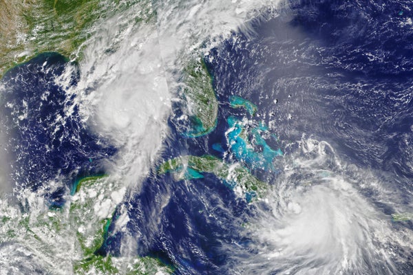
Tropical Storm Marco has already fizzled out but not before it brought some significant rains to the Gulf Coast. Hurricane Laura looks to pose a greater threat, with its “cone of uncertainty” (the range of possible tracks that meteorologists predict the hurricane might take) showing it potentially hitting the coast of western Louisiana or eastern Texas as a major hurricane.
On supporting science journalism
If you're enjoying this article, consider supporting our award-winning journalism by subscribing. By purchasing a subscription you are helping to ensure the future of impactful stories about the discoveries and ideas shaping our world today.
To break down how unusual it is to have two storms so close together—and where climate change fits in with hurricane trends and risks—Scientific American spoke with J. Marshall Shepherd, a meteorologist and professor at the University of Georgia.
[An edited transcript of the interview follows.]
How unusual is it to see two storms in the same area of one ocean basin?
I don’t think it’s unusual at all to have more than two storms in one basin; we see that all the time in the Atlantic or Pacific basin. Now it’s pretty unusual to see two in the Gulf of Mexico around the same time. In fact, if both storms had been a hurricane in the Gulf of Mexico—at one point, it looked like that was a possibility—I think that would have been unprecedented in the satellite era [since about the mid-1960s]. But even now, to have a situation where we’re seeing, in the week building up to this, two cones of uncertainty essentially crossing each other within days—that’s bizarre.
What conditions have allowed these two systems to develop so close together in time and space?
All along, we knew this was going to be an active Atlantic hurricane season. The waters are very warm, and in the Gulf of Mexico right now, they’re some of the warmest on the planet. And this time of year is also when we start to see more of a relaxation of wind shear [when winds blow in different directions at different levels of the atmosphere]. So that’s why, typically, the peak of hurricane season tends to ramp up after about August 20. This is also the time of year when we start to see less dust, [which can impede storms], coming off of Africa. There’s some other sorts of things that are going on in the background: There’s something called the Madden-Julian oscillation and Kelvin waves [patterns that move through the atmosphere and impact the weather]. And we could kind of see that the activity was going to pick back up, because there was going to be a phasing of these [phenomena] that would lead to sort of a general push upward of the atmosphere. You get more uplift.
What can we say about the role of climate change in fueling a situation like this one?
I think this sort of generation of earlier and warmer water is very consistent with what we would expect in a climate-changed environment. We’re just in an era of high-octane hurricane fuel. I think Hurricane Laura also has a reasonable chance of rapid intensification (which is a certain amount of pressure drop over 24 hours) in the Gulf of Mexico. And again, that’s just, in part, fueled by these superwarm waters that we have out there in the Gulf of Mexico. One of the things that often gets missed in discussion about climate change is that most of the warming is in the ocean—90 percent or more. And as I’ve often said in some of my lectures, all of that warming is going to find its way back to the atmosphere somehow. Hurricanes are one way that it does that.
I think there’s some pretty compelling evidence that has been coming out in recent years—although it’s not clear that either of these storms will do this—but I do think there’s pretty solid evidence that climate change is causing storms to slow down or linger more—in some cases, stall out, as we've seen with [Hurricane] Harvey and Florence. I think we’ve seen a more northward shift in intense storms. We’ve seen that even earlier this season, when we had some tropical storms forming up in the mid-Atlantic and Northeast, on the very fringes of where we tend to see these things. I think if we do get a Category 3 or greater storm, as some models indicate with Hurricane Laura, that would just be continuing the trend of these really intense storms—rapidly intensifying storms.
Finally, one more thing I’d say about climate change and hurricanes is something I’ve been convinced about for a while: I published a paper in the peer-reviewed literature, back in 2007, looking at “What are the contributions of hurricanes and tropical storms to coastal rainfall?” I was actually trying to set up a baseline for a future study, because I wanted to know how much annual rainfall hurricanes or tropical storms contribute, on average, in coastal regions around the U.S. I haven’t done the follow-up, but I suspect that hurricanes have probably become wetter. I suspect that they’re just more prolific rain producers. You often hear that climate change is a threat multiplier for national security, but it’s an impact multiplier for hurricanes.
What are the added risks with back-to-back storms hitting the same area, as might be the case with Laura and Marco?
One is that we're in a pandemic. So that complicates evacuation plans if there are shelters that would normally be open that are closed because of COVID-19—or if you are in a shelter with a lot of people, and that elevates the risk because of COVID-19.
Secondly—I was a little bit more worried about this over the weekend, when it looked like Marco was going to remain a hurricane—but can you imagine people just recovering even from just flooding and maybe minor wind damage, only then to turn around, 48 hours later, and have to deal with perhaps an even stronger storm? Logistically, it’s difficult enough to prepare for and recover from one storm.
One other thing that I saw talked about on Twitter—I really hadn’t thought about it, but actually it’s a great point—is: How are some of our storm surge models, and some of the other things that we use for warning of hazards, going to respond to back-to-back storms? Can they reset and calibrate themselves when the ocean is perhaps not doing what some of the assumptions and parameterizations of the models are saying it should do?
As we’re approaching the 15th anniversary of Katrina, how has our understanding of hurricanes and the role of climate change altered since then?
I think we have improved in our track forecasting in [the past] 15 years; the cone continues to narrow, so to speak. I think if you looked at the same cone for Katrina today versus 15 years ago, it’d be a lot narrower today. Unfortunately, still, we’re struggling a little bit with intensity forecasts. There’s some improvement, but as we’re seeing even with Marco and with Laura, the intensity forecast is still very tricky. That’s just because some of the physics that we need for the models are happening at scales that we don’t often have measurements for in the same way we have for large atmospheric steering currents from soundings [such as weather balloons].
I was one of the authors on the National Academies [of Sciences, Engineering, and Medicine’s] extreme-weather-attribution report back in 2016, which looked at where we are on climate change attribution to extreme weather events. We found that we were pretty conclusive and confident in the fact that heat waves, extreme rainfall events, perhaps some drought events and lack of cold events were highly attributable to climate change. Hurricanes fell more into the middle. And that’s simply because, in that report, we used a “three legs of a stool” approach: climate models had to be able to reproduce the event, you had to have good physical understanding of the event, and you had to have a significantly robust enough record. I think in 2005 we probably had even less ability to attribute some aspects of climate change to hurricanes. In 2020 I think that the attribution signal—at least on the intensity and perhaps on the stalling and northward migration of stronger hurricanes—I think we have a bit more information on that. I’d say today we have much more sophisticated and better attribution studies. If we were to write that National Academies report now, I think the hurricane attribution signal probably would have moved up the scale some.