Editor’s Note (10/16/19): This article has been edited after posting for inclusion in the November 2019 issue of Scientific American.
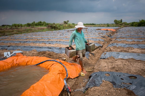
A stunning 12 million people could be forced to retreat from rising seas in Vietnam’s Mekong Delta within half a century. Geographer Philip Minderhoud and his colleagues at Utrecht University in the Netherlands arrived at this conclusion after analyzing ground-based topography measurements to which outside scientists’ access was limited for years. The new analysis, published in August in Nature Communications, shows that the Mekong’s elevation above sea level averages just 0.8 meter—almost two meters lower than commonly cited estimates.
The locally measured figures more than double the number of Vietnamese people living in low-lying areas that will be inundated as the earth’s climate warms, with some places likely to be underwater in only a few decades.
On supporting science journalism
If you're enjoying this article, consider supporting our award-winning journalism by subscribing. By purchasing a subscription you are helping to ensure the future of impactful stories about the discoveries and ideas shaping our world today.
For elevation readings in many developing countries, international researchers rely on freely available global satellite data because there are few on-the-ground records—and because some governments closely guard their own data. But satellite elevation readings can be notoriously unreliable in low-lying areas. Torbjörn E. Törnqvist, a geologist at Tulane University, says this is a concern not just for the Mekong but also for other mega deltas inhabited by tens of millions of people (such as the Ganges in Bangladesh and India and the Irrawaddy in Myanmar). “My hope is that these findings will wake people up to the fact that we’re dealing with terrible data sets that aren’t appropriate for the problems these deltas are facing,” he says.

Credit: Mapping Specialists
Unlike rocky continental coasts, deltas are made of soft river sediments that are deposited over thousands of years and can easily compact and subside. Subsidence can grow worse when upstream dams block the incoming flow of new sediments in rivers or when groundwater or natural gas is pumped up from below, removing underlying support for the land. Urban infrastructure can also prevent water from seeping into the earth and refilling aquifers. All these forces are at play in the Mekong, which is subsiding in some areas at rates approaching five centimeters a year—and the rate at which the entire delta is subsiding is among the fastest in the world. According to Nguyen Hong Quan, a hydrogeologist at Vietnam National University, flooding has grown more common all across the delta.
Numerous international assessments of deltas are based on topography information gathered in February 2000 by the space shuttle Endeavour. Known as the Shut-tle Radar Topography Mission, this global survey was sponsored in part by the U.S. Department of Defense, and data from the project are now publicly available. Elevation assessments use other space-based measurements as well, but in general they are prone to vertical errors ranging up to 10 meters or more. “Not so bad if you’re modeling the Himalayas,” Törnqvist says. “But for a low-lying delta, that’s a whole different story.” Organizations such as the World Bank rely on these assessments when making policy decisions, including where to allocate flood-preparedness resources.
The gold-standard remote-sensing system used for measuring delta heights—lidar, which is often mounted on aircraft—is accurate to within a few centimeters. But it is expensive and generally unavailable in developing countries.
Space shuttle data had put the Mekong’s average elevation at 2.6 meters. But Minderhoud, who was on-site with a Dutch research team studying the delta, was skeptical. He found that those measurements had strange elevation patterns that were inconsistent with the local terrain. Minderhoud says his Vietnamese colleagues knew their government had been collecting ground-based survey data and even some lidar measurements. Vietnamese academics, however, had not published the data in international journals, according to Minderhoud.
Robert Nicholls, a coastal engineer at the University of Southampton in England, says it is not unusual for governments to withhold topography measurements for national security reasons. Because those data can be used to support strategic military operations, “they are not in the public domain,” Nicholls says. And governments may simply not want to stir drama among local populations, Törnqvist notes.
To gain access to the Vietnamese data, Minderhoud first had to build trust with government institutions and identify opportunities for cooperation. “I tried to find out how my own research might contribute to their goals,” he says. “The key was to make this a combined effort.” In time, he wound up with almost 20,000 elevation points measured throughout the delta.
Minderhoud’s team also performed a crucial step that is frequently neglected in regional assessments: the researchers calibrated the data to a local benchmark for zero elevation at an island town called Hon Dau. This was necessary because ocean currents and other forces can cause water to “pile up” along certain local coastlines, making sea surfaces higher in some areas. The more typical approach is to use a global benchmark for zero elevation, which may not reflect local sea-surface height. By combining average rates for sea-level rise and for subsidence, Minderhoud estimates the water will effectively rise by 0.8 meter on average in 57 years.
A similar fate may await other major deltas. Heri Andreas, a researcher at the Bandung Institute of Technology in Indonesia, says Jakarta—coastal home to 10 million people and one of the fastest-sinking cities on earth—has been modeled extensively with lidar. Scientists estimate that almost all of the city’s northern district could be submerged by 2050, and President Joko Widodo announced plans to build a new capital on the island of Borneo. “But many other cities in Indonesia are also experiencing subsidence, and we don’t have accurate elevation models for most of them,” Andreas says.
Although the locally measured elevations are disturbing to outside experts, Nguyen maintains that they were not a surprise to scientists in Vietnam. He also says the Vietnamese government is developing what he claims is a new and even more precise elevation map. As for relocation, Nguyen says he is unaware of any plans to that effect. “The challenge is to convince people if the prediction is reliable enough to take action,” he says.