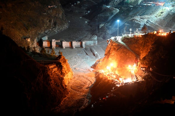
On Sunday morning a wall of thick, concrete-gray water rushed down India’s Dhauliganga river valley, sweeping dams, houses and people along with it. The official death toll has reached 38, but nearly 200 people remain missing. Flood debris filled a 12-by-15-foot tunnel at a hydroelectric dam project, where more than 30 construction workers remain trapped despite six days of rescue efforts by nearly 600 responders.
The deluge also wiped out five bridges, some of which ran 40 feet above typical river levels. This cut off access to 13 villages; the national government has been bringing in aid via helicopter and zip line as workers hasten to rebuild these vital connections.
The disaster laid bare a tension between the desire for economic development and the natural hazards of an already dynamic mountain range undergoing changes in the warming climate.
On supporting science journalism
If you're enjoying this article, consider supporting our award-winning journalism by subscribing. By purchasing a subscription you are helping to ensure the future of impactful stories about the discoveries and ideas shaping our world today.
SOLVING THE FLOOD MYSTERY
Much of the initial news coverage of the disaster reported it as a glacial lake outburst flood, which happens when a glacial lake breaches a natural dam of ice or debris and rapidly empties its contents. This kind of flooding is more common in the warmth of the summer—but it at first seemed like a reasonable explanation because Himalayan glacial lakes are growing in size and number as the climate changes, says Saurabh Vijay, a glaciologist from the Indian Institute of Technology, Roorkee.
This idea was quickly proved wrong, though, by an army of more than 130 miniature “cube” satellites, launched over the past six years by San Francisco-based private company Planet Labs. “They provide a snapshot of everywhere on Earth, every day,” says Dan Shugar, a geomorphologist at the University of Calgary. Roughly six hours after the flood, Shugar pulled up the latest Planet Labs satellite images and discovered a trail of dust and a dark scar on the pearl-white peaks above the flood zone—clear signs of a landslide.
Shugar consulted with other researchers on Twitter and soon homed in on the landslide’s origin. He saw that an enormous hanging glacier, roughly 15 football fields long and five across, had broken from the steep face of a mountain and plummeted downward, bringing some of the rock face down with it. Shugar says this ice and rock avalanche crashed into the Ronti Gad, a smaller tributary that feeds into the Rishiganga and then Dhauliganga rivers.
Actrually, it looks like it may have been a landslide from just W of the glacier. See here. Possibly from the steep hanging glacier in the middle of the Google Earth image. pic.twitter.com/6ImcwI91d7
— Dr Dan Shugar (@WaterSHEDLab) February 7, 2021
The landslide would have displaced some water, and a growing number of scientists agree with this analysis now. Still, the flood’s magnitude was far greater than would be expected in such a case. So, the question remains: where did all this water come from? Experts studying the disaster have proposed a few possibilities.
In one scenario, landslide debris may have briefly halted the flow of the Rishiganga river, says Umesh Haritashya, an environmental geologist at the University of Dayton. This could have created a temporary lake that eventually broke through its debris dam and poured down the valley.
“Put a stopper in the bottom of a bathtub, and the bathtub fills up pretty quick,” Shugar says, “It doesn’t have to take long to create a small lake.” But he also explains that the friction of an avalanche creates a lot of heat, which could have melted much of the ice tumbling down the mountainside. “It's entirely plausible that all of that ice melted, just about instantaneously.” The cascade may have also impacted ice and frozen sediments in the valley and melted those, too.
Some still believe the event could be related to a glacial lake outburst flood, suggesting that a lake hidden beneath or within a glacier may have ruptured. No surface lakes were visible, and a team of scientists from the Wadia Institute of Himalayan Geology has trekked to the landslide site in hopes of finding on-the-ground clues to solve the mystery.
A CONTROVERSIAL POWER SOURCE
Sunday’s flood wreaked havoc on multiple hydroelectric dams. It destroyed one called the Rishi Ganga Power Project and severely damaged another, the Tapovan Vishnugad project, which was still under construction at the time. Most of the people reported missing had been working on these dams.
Hydropower projects can draw communities closer to rivers and thus put them in harm’s way, Haritashya says. He has seen sprawling towns grow around dams, increasing the likelihood of a natural event becoming a tragedy. “People live close to the dangerous area, and there’s no proper rules and regulations to avoid it, or at the least they’re being [flouted] in many cases,” he adds.
The Indian Supreme Court recognized the risks of hydropower projects in the high mountains after an even bigger flood struck Uttarakhand in 2013, killing thousands of people and damaging 10 hydroelectric dams. The court indefinitely prohibited permits for new hydropower projects in the region, citing the danger the dams can put people in. It also noted the dams’ potential contributions to additional landslides and floods, as blasting mountainsides and clearing trees for dam infrastructure can make the landscape more unstable.
Yet the projects continued. “The country is energy-hungry,” Haritashya says. “These hydroelectric power dams are not going to be stopped.”
However, he adds that steps can be taken to boost safety. In addition to discouraging people from settling around dam sites, he says planners must carry out more thorough hazard assessments when choosing where to build hydroelectric dams, as some locations will be safer than others.
Developing hydroelectric power projects in safer ways and better locations will require close coordination between scientists and policymakers, Haritashya notes. But he says it may be time to look to other ways of producing hydropower. Local activist Dhan Singh Rana says communities in the region would strongly favor small-scale “micro-hydro” projects over bigger dams, as these would fulfill the energy needs of mountain communities without as much of an environmental or cultural impact.
HIMALAYAS AT THE CLIMATE EDGE
The Himalayas make up a growing and ever-changing mountain range that has seen innumerable floods and landslides over its lifespan. “These things happen, and they have happened always,” says Fabian Walter, a glaciologist at the Swiss Federal Institute of Technology in Zurich. “But we believe that climate change will make [them] worse.” And the effects of a warming climate are making it even harder to assess what hazards lurk in amidst the icy peaks.
“The health of Himalayan glaciers is deteriorating,” says Vijay, the local glaciologist. Himalayan glaciers are melting twice as fast in the 21st century as they were from 1975 to 2000; this has disrupted glaciers that were once sturdily frozen in place. With that in mind, Vijay thinks researchers should monitor hanging glaciers (ones that cling to steep mountain faces) more closely. By reviewing old satellite images, he learned that the hanging glacier responsible for Sunday’s landslide had developed a large crack in 2017.
Dave Petley, a landslide researcher at the University of Sheffield, says that “we’re not putting the same level of rigor into assessing the landslide hazards as we are in the seismic hazards.” Doing so will become critical, Petley adds, as big mountain landslides have become more common in the Himalayas due to thawing permafrost and more intense storms.
Unfortunately, Sunday’s devastating flood probably won’t be the last for the region. “We are likely to see more of such extreme events,” says Ravi Chopra, director of the People’s Science Institute in Uttarakhand. “The sooner we act on the warnings of the environmentalists, the better off we are likely to be.”