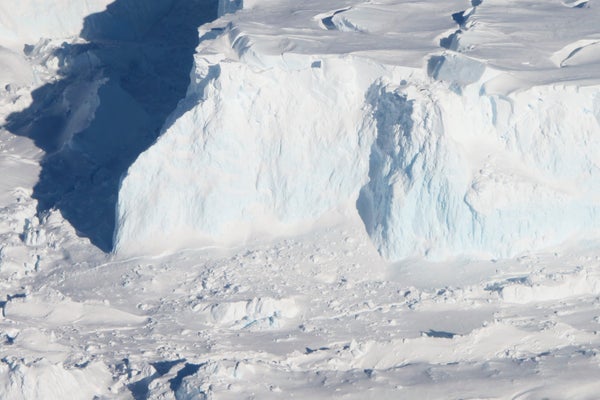
If Thwaites Glacier goes, so might the entire West Antarctic Ice Sheet. Thwaites has long been recognized as a linchpin for the massive expanse, which covers an area the size of Mexico and could unleash more than three meters of sea level rise were it all to melt. Thwaites alone is losing 50 billion tons of ice a year, and recent research suggests the glacier has already entered an unstoppable cycle of melt and retreat that has scientists seriously worried.
Glaciers are essentially rivers of ice. Like other Antarctic glaciers Thwaites flows toward the sea—and once there its ice begins to float, forming what is called an ice shelf. This shelf then acts as a doorstop that pushes back against the glacier’s flow. But warm ocean water has been nibbling at Thwaites’s ice shelf; as it thins, the ice behind it flows faster. That same water can chip away at the glacier’s “grounding line,” the place where the glacial ice meets the sea and where rock ridges currently help anchor it. If the ice thins enough, it could separate from those ridges, causing the grounding line to recede. And because Thwaites and much of the rest of the ice sheet rest on bedrock that sits below sea level, any retreat of the grounding line lets water penetrate farther inland, melting more ice and further speeding glacier’s flow. Because Thwaites drains the very center of the larger ice sheet system, if it loses enough volume, it could destabilize the rest of the entire West Antarctic Ice Sheet.
Scientists have been trying for years to conduct a major study of the remote glacier, in order to get an up-close look at these processes driving its retreat and to search for clues as to how quickly it could disappear. Now they are finally getting the opportunity with a $25-million joint U.S. and U.K. expedition involving eight projects that will poke and prod every aspect of the glacier and its environment—the climate science equivalent of a new Mars rover mission. The five-year effort will use tools ranging from radar devices dragged across the ice to image the glacier’s interior to autonomous underwater vehicles to sensors attached to elephant seals.
On supporting science journalism
If you're enjoying this article, consider supporting our award-winning journalism by subscribing. By purchasing a subscription you are helping to ensure the future of impactful stories about the discoveries and ideas shaping our world today.
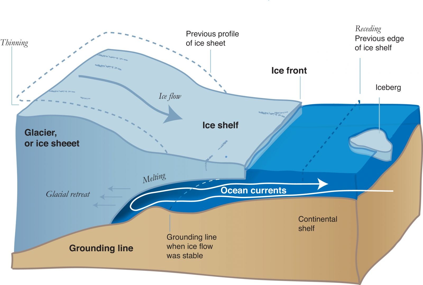
The bedrock below Thwaites Glacier slopes inward toward the continent, which allows warm, deep ocean water to flow downward under the ice shelf, chewing away at the grounding line. Credit: NSIDC and NASA
The data gathered will be plugged into climate models that will hopefully generate a clearer picture of what the future holds for Thwaites and West Antarctica, says project co-leader Ted Scambos of the National Snow and Ice Data Center. Scientific American spoke with Scambos about the scientific importance of the mission—called the International Thwaites Glacier Collaboration—and about exactly what researchers will be looking for when they set out in October 2018.
[An edited transcript of the interview follows]
Why is the melting of Thwaites a concern for the U.S. and other distant areas?
What we’ve learned, actually, is that when you move this amount of mass—trillions of tons of ice—around, you actually change, just a little bit, the gravitational pull that the continent has on the ocean around it. So not only does sea level on average go up but—ironically, I guess—in the vicinity of the ice sheet that’s losing ice, sea level actually drops because the continent doesn’t pull the ocean against it quite as much as it used to. What that means is that if, on average, you get one meter of sea level rise by the year 2100, most of the tropical areas of Earth will see 1.2, 1.3 meters of sea level rise. And so it actually means bigger problems for Florida and Texas and Bangladesh and Shanghai—low-latitude coastal cities and low-lying areas.
What makes the evolution of Thwaites so hard to predict?
It’s hard to know exactly when the glacier is going to thin enough to release from these areas of the grounding line that are currently holding it back, and also hard to predict how that acceleration—the speedup of the glacier—is going to unfold as the ice continues to thin.
The issue that’s come up more recently, and the one that actually has people worried about changing the timescale [of retreat] from a few centuries to several decades, is what’s called “marine-ice cliff instability.” And what that means is that if, by some process—probably having to do with surface melting—you suddenly remove the front of the glacier and have it calve back to where all of the floating part is gone and there’s just a tall cliff over a hundred meters tall at the waterfront, that cliff is inherently unstable. The stresses at the top of that cliff are enough to fracture ice immediately, and so you get into a situation where the cliff, as soon as it’s formed, begins to collapse. But the ice behind it is thicker, and so that cliff is even less stable.
What we’ve seen in Greenland is that these processes are underway for a short while, and the ice sheet certainly thins and flows much faster than it did before the beginning of the retreat. But it seems as though the marine-ice cliff instability is temporary, because the ice is deforming so fast anyway. So the question is: Just how is this all going to unfold?
Can you talk about what some of the projects will explore?
The core of it is really these studies that focus on the ocean and the ice interaction at the front, because that’s where we think things are going to be triggered. So there [are] two studies that are aimed at looking at how the ocean that’s right up against the front of the glacier interacts with the glacier ice—how it melts it out, how fast it melts out.
The other aspects of these studies in front are to really map out the ocean currents and temperature profile in detail. One of the assistants, or collaborators, that we’re going to have are seals that will have a little instrument pack strapped to them that will measure the profile of ocean temperature and salinity every time they dive down to get food. We’re planning to use elephant seals. They’re incredible divers; they’ll go as much as a kilometer below the surface of the water. And they dive 15, 20 times a day, so we get a tremendous amount of information.
And then the really tough place to make measurements is underneath the floating ice shelf, underneath this thick plate of ice. You have to have a submersible that will go fairly deep—hundreds of meters down below the surface—and then really navigate by itself and make decisions on its own, about whether or not it needs to go up or down or around any kind of obstacle that it encounters…right to the point where the glacier first goes afloat.
There’s also some new instrumentation that we’ll install from the surface of the ice, where we use a hot-water drill. We’ll go maybe a thousand feet through the ice and then lower a string of instruments into the ocean. We’ll do that at three or four places and get year-round measurements of what’s going on underneath. So, if that ain’t a science adventure, I don’t know what is.
What are some of the features you’ll be looking for in the data—for example, from the underwater autonomous vehicles and the radar traverses of the glacial surface?
In the traverses that are driving over the glacier to get a profile of what the glacier ice is like and what the bedrock is like below it, we’re going to be looking for where the glacier is frozen to the rock below and where it’s thawed. (It’s going to be thawed in most places.) And then also where there are patches of soft sediment. This stuff is like toothpaste, basically; it’s completely pulverized rock, and smeary and sticky and slippery. And that’s a big reason why glaciers in West Antarctica can flow very quickly. The other thing that they’ll be looking for on those traverses is how the ice is deforming, and we can actually measure that by how sounds waves pass through the ice.
In general [the autonomous vehicles are] going to be [measuring] temperature and salinity. And then the more sophisticated one…will use sonar to map in detail [as] it’s flying over the seabed—and then also what the underside of the ice looks like in detail. Those structures tell you things about what’s going on at the grounding line, because the ice at the grounding line is flowing away and out to the ocean at several kilometers per year. At 10 kilometers [out], what you’re looking at used to be grounded on bedrock at the edge of Antarctica just two or three years earlier.
How do you do such intricate studies in such a remote area, and how excited is the team?
Planning, planning, planning—and a lot of spares for the critical components. We’re just going to have to hope for enough luck and enough skill to get through the first few seasons, and get the real data that we’re after out of all of this.
It’s going to be a heck of a lot of work. The e-mail traffic alone is already just enormous. But we’re excited to be able to get out there. It’s going to be remote. There’s going to be days when we hate ourselves for having signed up for this. But in the end it’s going to be a great story, both for science and—I’m going to be frank with you—for adventure as well.