[Editor's note: This story was updated at 9:45am on January 28 to note the unmapped area of Antarctica.]
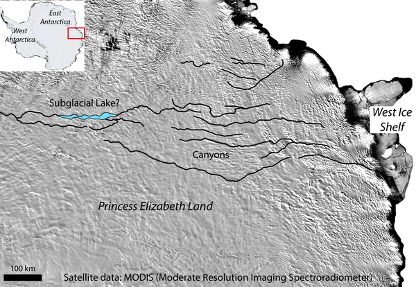
Tucked beneath East Antarctica’s vast ice sheet is a frozen world, complete with subglacial lakes, rivers, basins, volcanoes and mountains. But roughly 91 percent of Antarctica—nearly twice the size of Australia—is unmapped, and the largest unsurveyed region on the icy continent is a region called Princess Elizabeth Land. Now a team of geologists has scoured that area to reveal a massive subglacial lake and a series of canyons, one of which—more than twice as long as the Grand Canyon—could rank as Earth’s largest. The findings indicate the ice sheets are less stable than previously thought, and could be strongly affected by climate change.
Stewart Jamieson from Durham University in England and his colleagues made the discovery by looking for subtle changes in the ice sheet’s surface shapes, developed as a result of ice flowing over diverse topography. For years geologists have thought that hidden features could subtly sculpt the surface above, leaving ghostly hints in the ice. An unwrinkled ice sheet, for example, might reveal a buried subglacial lake whereas an undulating one might signal a hidden mountain range. So with satellite images of such surface features as a guide, Jamieson and his team used ice-penetrating radio waves—which bounce back as echoes, like radar--to help map the topography underneath.
On supporting science journalism
If you're enjoying this article, consider supporting our award-winning journalism by subscribing. By purchasing a subscription you are helping to ensure the future of impactful stories about the discoveries and ideas shaping our world today.
Their analysis, recently published in Geology, reveals a subglacial lake covering as much as 1,250 square kilometers (making it the second-largest subglacial lake in Antarctica by length after Lake Vostok) and a series of canyons that extend a kilometer deep and 1,100 kilometers across. It is a tantalizing first glance at such an uncharted region, says Dustin Schroeder of Stanford University, who was not involved in the study.
The results, and other subglacial analyses, will better equip geologists in understanding how the ice sheet responds to climatic changes. The amount of future sea level rise, for example, directly depends on the ice sheet’s thickness, which varies over these lakes and canyons. Not only can a thicker ice sheet above a canyon potentially melt more water but it likely runs deep—so deep that the ice sheet’s base is well below sea level. Any parts of the bed this low are easily exposed to ocean water, allowing the ice sheet to weaken from below as the ocean water warms. Although this is a big concern for West Antarctica, geologists have always thought East Antarctica’s bed was above sea level—for the most part—and therefore more stable, says Peter Fretwell from the British Antarctic Survey, who was not involved in the study. But new analyses like this, which show previously undiscovered deep canyons, suggest that a good chunk of East Antarctica’s bed lies below sea level, rendering the ice sheet less stable than previously thought. In fact, the total area grounded below sea level might be greater for East than West Antarctica, Fretwell says.
The region beneath Princess Elizabeth Land is so exciting that geologists are making wilder predictions, too: First, Jamieson suspects that the linear features, or canyons, might actually point to rifting, where two tectonic plates are prying themselves apart. Second, Neil Ross from Newcastle University in England, a co-author on the study, speculates that the lake could contain microbial life. Any microbes would “have been isolated from the rest of the planet for an awful long time and might have unique adaptations as a result,” he says. Such microbes could aid our search for life in the outer solar system.
Although the subglacial topography is vastly important, “it's unlikely we're ever going to [map] the whole of Antarctica in great detail using radar echo sounding—it's just too costly,” Fretwell says. Instead, a simple analysis like this could be a good starting point. If it churns up an interesting feature, then geologists could target that area with better radar. In Princess Elizabeth Land the team is doing just that by using airborne radar to verify the existence of these subglacial features and better map the region.