Before it became a flashpoint in an antigovernment protest, the Malheur National Wildlife Refuge was a place where dozens of scientists conducted research projects aimed at studying the plants, animals and ancient cultures who lived in eastern Oregon’s high desert. Despite some indication that the ordeal might soon be over, with only four militants still occupying the refuge at press time as the standoff continues into its fourth week, concern that the militia’s activities could have long-term effects on the refuge’s ecosystem and archaeological sites is growing.
Malheur is unique because it contains a variety of environments including sagebrush steppe, salt desert scrub, stands of willow, wetlands, open lakes and wet meadows. This diverse ecosystem attracts hundreds of bird species, which humans have been hunting for at least 9,800 years. “It’s a critical place for science, for visitation, and bird-watchers,” says U.S. Fish and Wildlife Service (FWS) Public Affairs Officer Megan Nagle, “but it’s also critical to us as people and our cultural history when we look at the land use over thousands of years.” Thousands of prehistoric and historic artifacts that provide insight into the lives of the Native Americans and ranchers who have called Malheur home are stored at the refuge’s headquarters.
Theodore Roosevelt created Malheur National Wildlife Refuge in 1908 because of the area’s unique ecosystem and extraordinary beauty as well as to save migrating birds from being hunted to extinction. The refuge is an important part of the Pacific Flyway, a migration route used by hundreds of bird species, 320 of which still routinely visit the area. The main portion of the refuge was purchased in 1935 using Civilian Conservation Corps (CCC) funds and it was expanded again in 1942. During this time the CCC built roads, bridges, canals, dams and fences for the purposes of restoring habitats and making the refuge—managed by the FWS—more accessible and usable for its more than 100,000annual visitors.
On supporting science journalism
If you're enjoying this article, consider supporting our award-winning journalism by subscribing. By purchasing a subscription you are helping to ensure the future of impactful stories about the discoveries and ideas shaping our world today.
Today, there are 25 active biological monitoring projects at the refuge, according to the FWS. These projects are meant to provide information about how the environment and the animal species are changing. Such monitoring also helps the FWS make decisions about leasing grazing rights to ranchers, which is an important tool for controlling invasive grasses. Much of the science conducted at the refuge involves its tremendous variety of plant and animal life but also includes important archaeological excavations.
The archaeology work at the refuge became one of the occupiers’ complaints against the government on January 20 when the militia released a video showing one of their leaders, Robert “LaVoy” Finicum, and others inspecting cardboard boxes of stone artifacts that had been recovered from the refuge. Finicum, who was killed in a confrontation with law enforcement officers on Tuesday, expressed dismay over the treatment of the artifacts and asked for a liaison with the Burns Paiute Tribe to discuss returning the artifacts to them. The tribe has responded by enacting a resolution calling on the U.S. Department of the Interior to prosecute the militants to the fullest extent of the law citing federal government’s treaty obligations. “We have a long standing relationship with the tribe,” says Malheur archaeologist Carla Burnside of the Native Americans who are descendants of the land’s original inhabitants, “they are involved in every aspect of the work we do out there.”
Right now an archaeological survey is underway at the refuge to relocate some sites that were discovered in the 1970s but they are also identifying new ones in the course of the work. Archaeological work at the refuge is limited to sites that are in danger of being damaged. Burnside’s philosophy is that it is better to preserve the refuge’s archaeology for future generations rather than excavate it.
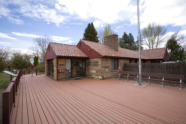
One of the sites that has, until now, been left intact happens to be the headquarters buildings the militants are occupying. They have been using a bulldozer in the area around those structures. The headquarters buildings and prehistoric sites near them are listed on the National Register of Historic Places. “If soil is being disturbed out there, it is highly likely that they have impacted prehistoric resources,” Burnside says. Damaging a site listed on the Register is a violation of the Archaeological Resources Protection Act of 1979 and could add to the list of charges facing the militants.
If the standoff does not end soon, as many hope it will, further damage is on the horizon because people cannot get into the refuge for simple routine maintenance. For example, much of the water in the refuge’s lakes and rivers comes from snowmelt from the nearby mountains. “If that water isn’t moved properly and managed, it can do horrific infrastructure damage and ruin a lot of our habitat,” says Linda Beck a fish biologist at Malheur who is working to control the population of invasive carp that are destroying bird habitats. This is the time of year when maintenance crews would normally be repairing the canals, cleaning debris out of the dams, opening clogged irrigation pipes and generally doing what needs to be done to keep the water-control system working properly.
If normal operations are not restored soon, the invasive carp—which the refuge has been trying to eradicate since the 1950s and where progress has been made in reducing their numbers—could spread back into areas. Carp churn up the sediments at the bottom of the rivers and lakes they inhabit. Many of the plant species that the birds need for nesting and forage cannot survive in the resulting muddy water. The number of waterfowl breeding at Malheur has dropped by 90 percent since the carp invaded in the 1920s. Also, the “wet meadows” that many of the birds, such as the sandhill crane, rely on for nesting grounds may not get enough water. Malheur wildlife biologist Faye Healy describes the crane species as “big sexy birds,” one of the refuge’s main bird-watching attractions. Malheur hosts some 250 breeding pairs of the cranes, or about 20 percent of the Pacific Flyway’s population of sandhill cranes. Additionally, not having enough wet meadow habitat could have a major impact on the thousands of migrating birds that rely on Malheur for feeding and nesting grounds.
“We would like to be past this event in time for the birds to return safely,” says Miel Corbett deputy assistant regional director of the FWS’s Pacific Region. The major bird migrations begin in March and everyone seems anxious to start preparing. As Nagel put it, “folks want to get back to work.”