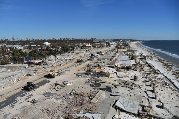
When Hurricane Michael barreled into the Florida Panhandle last October, the punishing waves whipped up by its winds blasted a 900-foot-wide gap in the sands of Cape San Blas, a narrow peninsula just a few miles east of where the storm made landfall. Much of a popular state park there was turned into an island overnight.
The transformation left officials with the potentially costly dilemma of whether—and how—to bridge the gap to restore access; it also exposed a weakness in the computer models that warn coastal communities about impending storms. Those simulations can predict how much ocean water will inundate a broad area, but are missing the small-scale details of coastal geography and wave physics that are needed to predict localized damage such as the washout of Cape San Blas.
New, more detailed data and improved computing power are allowing scientists to revamp their models to give coastal communities more precise information on which areas will be most vulnerable during a storm. Beyond forecasts, scientists also want to link models to a vast network of beach cameras that could provide real-time alerts. “This is really going to help communities understand what roads might go underwater, what bridge access could be cut off and where to stage equipment,” says Kara Doran, an oceanographer with the U.S. Geological Survey in Florida. “That’s going to help protect lives and property.”
On supporting science journalism
If you're enjoying this article, consider supporting our award-winning journalism by subscribing. By purchasing a subscription you are helping to ensure the future of impactful stories about the discoveries and ideas shaping our world today.
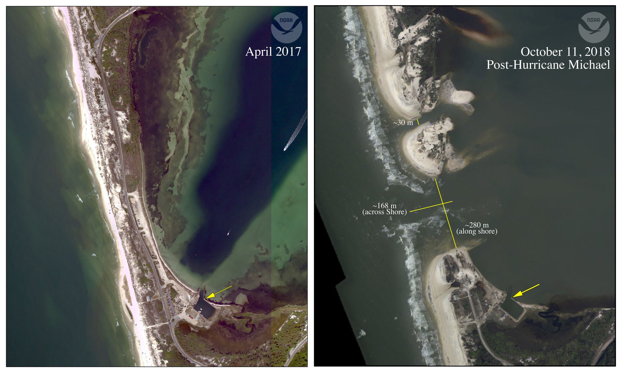
Storm surge and waves completely eroded and breached a low, narrow spot on Cape San Blas, creating two new inlets and severing the only road access to T. H. Stone Memorial Saint Joseph Peninsula State Park. The area had only a 26 percent probability of flooding, but the scale of the flood models likely did not resolve the low, narrow area that breached. Credit: NOAA and USGS
Missing Pieces
Coastal storm models do a good job of predicting how high storm surge will be based on the power of the storm and the broad shape of the coastline. But due to a combination of a lack of detailed data, limited funding and slower computers, the models have been missing several other key pieces that determine more localized flooding levels—from specific coastal geographies to the timing of storms.
One important missing piece is accounting for the waves that act on top of the storm surge—the rising water the storm pushes ahead of it. The strength of those waves can have a big impact on coastal flooding. “It’s really important, because that’s the energy that really moves the waves up the beach” and causes major erosion, says USGS oceanographer Hilary Stockdon. The grade of the coastal seabed and the terrain of the coast—such as sandy beaches, marsh or rocky cliffs—influence wave strength. Marshes, for example, attenuate waves, providing natural protection against flooding, compared with sandy beaches. Today’s models assume all coasts consist of sandy beaches because that landscape was of most interest to the U.S. Navy, which provided much of the funding for early model development. Higher-resolution coastal surveys done from planes have now given researchers the detailed data they need to include more shoreline types in models, Doran says.
The data can capture even small coastal features research has shown may create opportunities for serious erosion. The breach at Cape San Blas happened at a spot with a large, unpaved parking lot, where water could rush in unimpeded. “Had that parking lot been a tall, vegetated dune, things might have been different,” Doran says. Having such fine-grained details in flooding models might have tipped officials off to the major flood damage that would ensue.
Current models also do not account for the duration of storms, a shortcoming that became apparent in the aftermath of Hurricane Florence last September: Even though it did not have a massive storm surge, “it pounded the coast for days with large waves,” Doran says. At one spot beach sand was moved more than 650 feet inland by the persistent surge, increasing the coast’s vulnerability to future storms. Improved models will seek to factor in storm speed and duration, using National Hurricane Center forecasts to capture this interplay.
In addition to the flooding threat coming from the sea, rains and swollen rivers can add tremendous amounts of water to a region and combine with storm surge, an event called compound flooding. The deluge Florence unleashed over the Carolinas set at least 28 flood records there and helped keep floodwaters elevated for days. Now scientists are adding salinity readings—which show whether fresh- or salt-water is impacting a particular area—to the models so they can better predict compound flooding. The USGS is also working with the National Weather Service to combine river flooding and weather models to better capture the added flood impact from rain during a hurricane.
Looking to the Dutch and Surfers
High-resolution coastal models that feature these factors already exist—pioneered in the Netherlands, a nation that has to contend with a low-lying coastline, Doran says. “They have models that nearly track grains of sand moving in the water,” she says, and use them to proactively decide where seawalls or flood tidal barriers are needed. The U.S. is currently playing catch-up to that work, and must overcome several scientific, computing and policy hurdles to make models that can be useful as storms hit.
For one thing, the more details that are packed into models, the more costly and time-consuming they are in terms of the computing power needed to run them. So although the added detail could make simulations more useful for planning for various types of storms, “we can’t run them in a real-time mode for an approaching storm,” Doran says. That means scientists need to find a way to balance the wealth of available data with the need for quick answers during storms.
One way to incorporate more real-time information is via the growing network of private surfer, beach and weather cameras that have cropped up along U.S. coasts and have already generated viral clips of gnarly crashing waves around the Web. A public–private partnership called SECOORA is sharing real-time information, including video, along the east coast that can be used to, for example, make sure surge models reflect actual storm damage, says Joe Long, an associate professor of oceanography at the University of North Carolina Wilmington. The cameras could also be useful in providing real-time warnings as they gather data on conditions in the thick of storms. Long envisions a system that integrates these with weather models within the next five to 10 years.
Another challenge is putting all the pieces together in a form that local officials can use to prepare residents. “We're still in this learning period of trying to get the right information out, to the right person, at the right time,” Stockdon says. “It’s going to involve a lot of conversations between the scientists and the people in the communities who need that information.”
The hope is that eventually forecasts and warnings will improve enough to anticipate—and potentially even prevent—damage like the breach at Cape San Blas that has taken communities by surprise. Doran, for one, is optimistic: “I think there’s not really a reason that we can’t improve our models to reflect those small areas that turn into a big problem.”