A total eclipse of the sun occurs somewhere on Earth about every 16 months on average. But the narrow band of complete darkness often falls on remote areas, for a brief time. The upcoming August 21 total eclipse is uncommon because it will darken populated areas across the entire continental U.S. The last such event over the U.S. was on February 26, 1979, and that was limited to the northwestern region of the country, along with western Canada.
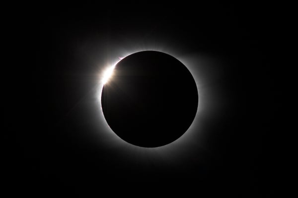
The sight of the sun’s dramatic corona, the quick drop in air temperature, the stirring of winds and the rapid rise back to daylight are all so striking that eclipse chasers are going to great lengths to experience these wonders.
The keys to maximizing your odds of success on eclipse day are watching the weather and planning for mobility.
On supporting science journalism
If you're enjoying this article, consider supporting our award-winning journalism by subscribing. By purchasing a subscription you are helping to ensure the future of impactful stories about the discoveries and ideas shaping our world today.
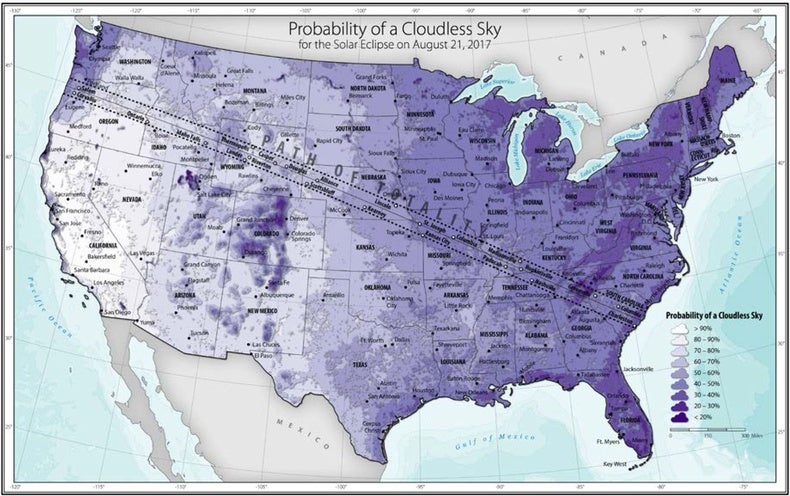
If you are free to travel widely, your best odds for clear skies are in the western U.S. from the Willamette Valley of Oregon to the Nebraska Sandhills (see map below). Many eclipse chasers are converging on favored locations such as Madras, Ore.; Idaho Falls, Idaho; Casper, Wyo.; and Alliance, Neb., because these locations have good prospects of clear skies. But even in the eastern half of the country you have a decent chance of cloudless skies, especially if you get close to the band of totality the day before, and then are willing to relocate a couple hundred miles on the morning of eclipse day.
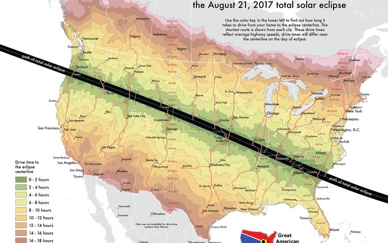
Drive times to the centerline of the August 21, 2017, eclipse, computed with ArcGIS software by Esri.com.
Map created by Michael Zeiler
If you can, plan your primary destination to be the closest place within your range of travel with the best climatological conditions. Then, watch the short-term weather forecast starting a week before and adjust your target destination if necessary. And maybe hope for a little luck: As the moon begins to partially cover the sun, a phenomenon called “eclipse cooling” begins: The lowering of air temperature may dissipate a thin cloud layer and save the day.
Mobility is the second key to success.
A big reason that this coming celestial event is called the Great American Eclipse is because half the nation’s population can reach the path of totality within a day’s drive (see map below). Over 174 million Americans live within 400 miles of the path, and the Interstate highway system provides many routes to prime locations.
Map courtesy of the National Renewable Energy Laboratory. Copyright © Alliance for Sustainable Energy
The trick, however, will be to avoid traffic choke points. I’ve done an extensive geographic analysis of how the U.S. population could converge on the highway system at GreatAmericanEclipse.com. I estimate that between 1.85 million and 7.4 million people will join the 12 million residents already living in the path of totality on eclipse day. This mass pilgrimage could produce the most significant traffic congestion in the nation’s history.
The map of my analysis, below, shows that travelers will converge on a set of highways that meet the centerline of the eclipse. Like small rivers flowing into a larger one, this pattern will amplify the congestion at points such as Salem, Ore., Idaho Falls and Columbia, S.C.
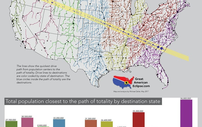
Population within the total eclipse band and predicted number of people traveling there on eclipse day.
Map created by Michael Zeiler.
Highways crossing the path of totality that are already prone to congestion will experience massive traffic jams on eclipse morning. Unsuspecting, and suspecting, drivers are also very likely to just stop in the road to look up at the incredible sight.
To avoid a complete shutdown on eclipse day, consider smaller local roads close to and inside the path of totality. And before you get to that day, consider the following wise moves:
—Arrive at least the day before to beat the predictable traffic jams. If you have no lodging arrangements, take a tent and sleeping bags because there will be many temporary campgrounds established in the path of totality.
—Take everything you will need for three days. Especially in smaller towns and rural areas, there will be shortages of food, water and other supplies. Keep your gas tank topped. Bring medicine, hats and sunscreen. Take chairs for the wait on eclipse day.
—After the eclipse, stay until traffic clears. You can view local traffic conditions with smart phone apps.
The sight of a total solar eclipse will remain with you for a lifetime. Your emotion as totality ends will be a mixture of giddiness at what you just experienced juxtaposed with a tinge of sadness that it is over. Luckily, the next total solar eclipse in the U.S. is in less than seven years, on April 8, 2024, bending northeast from Texas to western New York State.
Want more insights? Check out these resources:
Eclipsewise.com serves authoritative predictions and data for eclipses past, present and future.
Eclipsophile.com is the go-to site for eclipse weather forecasts.
GreatAmericanEclipse.com serves a cornucopia of maps, animations and information on the August 21 event.
Eclipse.aas.org delivers comprehensive advice for safe viewing and a gallery of images.
Xjubier.free.fr/en/site_pages/solar_eclipses/TSE_2017_GoogleMapFull.html is an excellent interactive eclipse map.
Eclipse2017.nasa.gov will serve live feeds on eclipse day and summarize the activities of NASA scientists.