When atmospheric scientist Thomas Lauvaux briefed Pennsylvania State officials on his measurements of local methane emissions four years ago, he converted the potentially dry list of numbers into a smattering of reddish bars on a map of the state. Emissions hotspots—from coal mines near Pittsburgh and farmland in the state’s southeast—clearly jumped out. Lauvaux sensed that such visualizations of the otherwise invisible gas plumes could help policymakers and industry leaders zero in on the sources of the greenhouse gases, particularly methane, that are fueling the world’s worsening climate crisis.
Although carbon dioxide is the most abundant greenhouse gas, methane has 80 times the warming power of CO2. More than a quarter of the earth’s 0.8 degree Celsius temperature rise since the Industrial Revolution is blamed on methane—generated by oil and gas production, fossil fuel–burning power plants and vehicles, millions of belching cows on industrial-scale farms, and landfills. To be able to take action, companies and state regulators need to know precisely where these sources are located and how much methane each one is emitting. Ground-based sensors, like those used to produce the map Lauvaux showed the Pennsylvania officials, cannot practically be deployed on a wide enough scale to pinpoint in detail all the various sources.
Satellites, on the other hand, can monitor large areas but take less detailed measurements. The respective limitations of these methods leave a gap in methane-monitoring efforts. But improved, cheaper satellite technology is starting to marry the broad coverage of satellites with something closer to the precision of ground-based measurements. This development could make it easier to spot currently unrecognized emissions sources and get more accurate measurements of known ones. Several startups and nonprofit organizations are capitalizing on this technological shift with the goal of helping companies understand the emissions levels of their business operations, and holding the worst polluters accountable.
On supporting science journalism
If you're enjoying this article, consider supporting our award-winning journalism by subscribing. By purchasing a subscription you are helping to ensure the future of impactful stories about the discoveries and ideas shaping our world today.
“Once we have this type of methane-tracking microsatellite actually pinpointing the emission source down to the [oil or gas] wellhead, then there are no questions” about where the methane is coming from, says Yotam Ariel, founder and CEO of Bluefield Technologies in Palo Alto, Calif., one of the companies involved in this effort.
---3---(Dec_-2018)(1).png?w=900)
Bluefield tested its methane-detecting sensors on helicopter flights over known emissions sources. Credit: Bluefield Technologies Inc.
Meet the Contenders
Historically, if scientists wanted detailed readings of emissions, ground-based sensors placed close to a source were the only option. Yet these are limited to particular sites unless teams of scientists drive around conducting time-consuming surveys, which are impractical on a large scale and are only deployed to measure known emitters. Satellites, however, survey large swaths of the planet. Their use of a single sensor also provides more consistency, making measurements from different spots directly comparable. Until recently, though, satellites have been prohibitively expensive and their spectroscopic sensors have lacked the precision of those closer to the ground, says Laure Brooker Lizon-Tati, an engineer with Airbus Defence and Space in Toulouse, France.
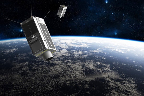
That dynamic started to change within the past decade, as broader industry demands drove the miniaturization of electronics and shrank the costs of rocket launches. This made it possible to develop smaller, cheaper satellites that carry sensors capable of zooming in on individual sites to capture high-resolution methane measurements. Companies and one environmental group have leaped at harnessing such satellite capabilities for industries and policymakers eager to pinpoint individual local methane sources. But governments and large aerospace companies, encumbered by lengthy planning processes, have been slower to pivot away from a focus on measuring methane emissions on a regional and global scale. In 2016 the Montreal-based company GHGSat was the first to get off the ground with a proof-of-concept satellite called Claire, which successfully detected methane emissions from specific sites.
A handful of other groups have followed suit. The nonprofit Environmental Defense Fund has enlisted several companies to develop what it calls MethaneSAT, which could provide weekly coverage of up to 80 percent of the world’s major oil and gas production sites once it launches in 2021. Its data would be made freely available to policymakers who want reliable, independent emissions measurements. And its wide global coverage means it can complement higher-resolution satellites, such as future ones planned by GHGSat that would focus on particular areas. The two groups also hope to collaborate on GHGSat’s planned database compiling measurements from sites around the world and using AI to analyze emissions trends among various companies, industries or areas in a way that could “be used to better control and reduce emissions,” says Stephane Germain, president of GHGSat.
Both industry and government regulators are taking an interest in these private satellite monitoring efforts. For example, Bluefield and the San Francisco–based company Planet Labs are working with the state of California on methane-monitoring projects that can pinpoint methane plumes coming from oil and gas facilities, landfills and even herds of dairy cows. And though Bluefield has not yet launched its first methane-tracking satellite (which is expected to happen in 2020), several of the largest oil and gas companies have also already signed on as Bluefield customers to measure and begin to rein in their emissions before policymakers can start to factor these new data into pollution regulations, Ariel says.
The independent perspectives these satellite companies would provide are also important because environmental groups and academic researchers have previously clashed with industry—and with regulatory agencies such as the U.S. Environmental Protection Agency (EPA)—about what the researchers say are underestimates of methane leaks, Lauvaux says, who is hosted at the Laboratory for the Science of Climate and Environment, University of Paris-Saclay, and has contributed to such studies.

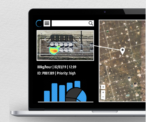
A mockup of how a plume of methane would show up on Bluefield’s user interface for customers. Credit: Bluefield Technologies Inc.
Making Satellite Data Matter
Whether or not companies such as GHGSat and Bluefield can deliver on their high-flying visions remains to be seen, according to Lizon-Tati, who is coordinating the European Union’s Space Carbon Observatory (SCARBO). That program aims to develop miniaturized sensors for cheaper, more frequent monitoring of both methane and carbon dioxide levels from space starting in 2030. “It is difficult to assess right now whether the sensors [the private groups] are developing meet the accuracy levels required to measure methane,” she says. So far GHGSat and Bluefield have been testing their methane detectors by measuring both known emission sources and controlled releases of methane, and comparing their measurements to those from ground sensors and government satellites.
Lauvaux hopes the companies building their own emissions-monitoring satellites will permit academics or federal labs to evaluate their methods. GHGSat has collaborated with research groups at several universities on published studies. Bluefield’s Ariel says his company is open to letting scientists download satellite data on methane emissions that are not commercially significant but remain scientifically valuable, such as emission measurements from decommissioned oil and gas wells, old coal mines, landfills or perhaps melting permafrost near the Arctic.
If these companies can help inaugurate a new era of satellite monitoring of emissions, their efforts could lead to meaningful changes on the ground in several ways. Enabling companies to swiftly spot and fix more methane leaks from wellpads and pipelines would already make a difference in addressing emissions, Lauvaux says. Yet there are also the intangible benefits, as more satellite data can help generate a clear visual picture of the “massive amounts of methane floating around” that would resonate more with ordinary people than numbers alone, Lauvaux says. And when enough members of the public get concerned, he adds, more officials may finally feel compelled to do something about it.
“Climate change is such a difficult concept to see for yourself: you cannot touch it, you cannot look at it,” Lauvaux says. “But when you start to see the methane pouring out of a tank, I think the satellite images are going to really talk for themselves.”
