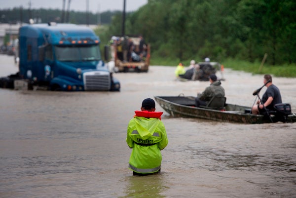
Hurricane turned Tropical Storm Harvey has pounded Houston since last Friday, dropping over 35 inches of water in some areas of Harris County within 72 hours. The heavy precipitation has led to massive flooding, leaving people either fleeing or stranded, waiting for rescue.
According to some estimates, the storm by Monday had already released 14 to 15 trillion gallons of water across the region. Rains have continued to thrash the city. Unfortunately, Houston has few options for draining its biblical deluge.
Why? First, Houston is very flat—it sits in a low-lying coastal plain. “This means the capacity for drainage is very slow,” explains Arturo Leon, a professor of water resources engineering at the University of Houston. “If there were a slope, then it would drain faster.” Second, over the past few decades, the city has grown rapidly, building cement highways and houses where wetlands once grew. Those wetlands traditionally would have helped soak up storm waters. And, experts say, as Houston developed at such a fast pace, the infrastructure to handle these kind of intense storms has not kept up. Of course Houston’s location near the coast also leads to floods. Housing and highways have been built on top of “a landscape that’s super prone to flooding,” explains Sam Brody, director of the Center for Texas Beaches and Shores at Texas A&M University. Now add the ridiculous amount of rain. “Our average annual rainfall in Houston is around 40 inches, and some locations are approaching that amount since the beginning of the storm,” explains Jeffrey East, surface water specialist at the U.S. Geological Survey’s Texas Water Science Center. “When you get a year’s worth of rain anywhere in a short period of time, it’s difficult for any system to handle.”
On supporting science journalism
If you're enjoying this article, consider supporting our award-winning journalism by subscribing. By purchasing a subscription you are helping to ensure the future of impactful stories about the discoveries and ideas shaping our world today.
#Harvey in perspective. So much rain has fallen, we've had to update the color charts on our graphics in order to effectively map it. pic.twitter.com/Su7x2K1uuz
— NWS (@NWS) August 28, 2017
Given Houston’s characteristics, it might seem like the city should have a high-tech solution ready to drain all that water. But it doesn’t. Houston essentially has to wait for nature to empty its floodwaters. The city has no pumps, like New Orleans does, orlevees and floodwalls that can open to release rising water. Instead, Houston relies almost solely on its bayous as its drainage system.
A bayou is basically a slow-moving, meandering creek or stream. Water from Houston’s 10 main bayous primarily flows from the west side of the city to the east, heads into the Houston Ship Channel, and then flows out into Galveston Bay in the Gulf of Mexico. But “we don’t have much natural slope,” says East, “Water moves slowly here.” The bayous are currently swamped, so although the flooding in Houston is widespread, “the intense stuff is where the bayous have overflown,” says Brody. “They’re out of their banks.” The city has no other alternatives. “Whatever is going to happen, there’s nothing the city can do,” explains Phil Bedient, a professor of engineering and director of the SSPEED Center for severe storm prediction at Rice University. “There’s no way to move this water faster.” He says that most bayous reach their capacity when hit by a 1-in-25-year storm, and experts are now saying Harvey has produced a 1-in-500-year flood. Relying on bayous alone is simply not enough.
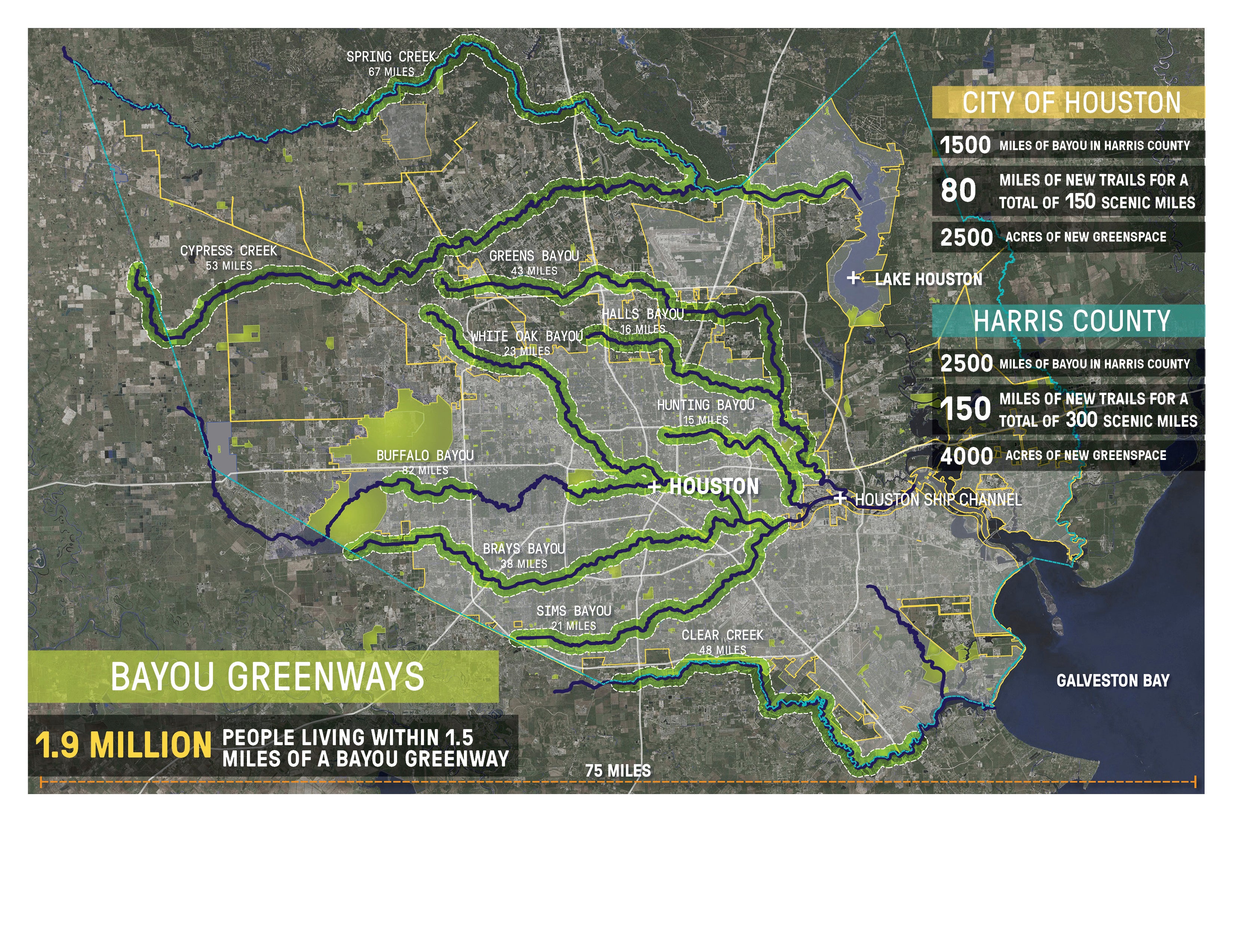
Credit: Jonnu Singleton / SWA Group
The city did build two flood control reservoirs decades ago to protect downtown Houston. The Addicks and Barker reservoirs have earthen mound dams with gates that can close to gather water from upstream waters that would normally flow into the city. After a storm, the Army Corps of Engineers—which runs the reservoirs—would open the dam gates and release controlled amounts of water into Houston’s Buffalo bayou, which runs through the city, slowly draining the reservoirs without flooding the city. Now, though, Addicks is reportedly over capacity, and water has begun spilling over the reservoir. Officials have told the media that they expect the Barker reservoir to begin overflowing as well. Water from those reservoirs will stream into downtown Houston. On Monday, the Army Corps began planned discharges of water from the reservoirs to ease pressure on the dams and to prevent uncontrolled releases of storm water. On Tuesday, a levee at Columbia Lakes in Branzia County, located south of Houston, was breached by floodwaters.
No one knows exactly how long it will take the bayous to drain the city of its trillions of gallons of water. The timing depends in part on how long it keeps raining and how much more precipitation falls. Jeff East says it will also vary depending on location—some local street flooding might drain in a matter of hours when the rain stops, whereas other sites might take half a day or more. But the bayous—the city’s drainage system—and the areas that surround them likely will not return to normal for days or possibly weeks, says East.
Most experts stress that Houston needs a better strategy for handling floods than the one it has now. “[After Harvey,] there’s going to be a much stronger initiative on making room for the water,” says Bedient. While some disagree on whether a pumping system would be a viable option, they point to preventive measures such as building elevated houses and highways above flood levels, expanding the reservoirs, relocating houses away from the bayous, restoring natural water-absorbing surfaces like wetlands (and protecting existing ones), and more. “I think there’s going to be big-time pressure for [major] policy changes on everything we do,” says Bedient. “Once we get through this.”