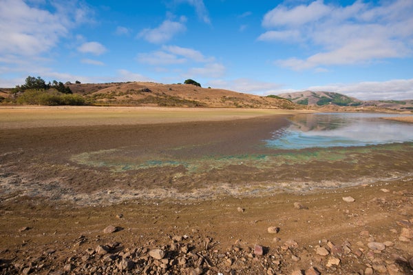
When experts predicted in 2014 and into 2015 the impending arrival of a major El Niño event for 2015-2016, Californians breathed a collective sigh of relief. The phenomenon marked by warm Pacific Ocean temperatures was predicted to bring substantial amounts of precipitation, which has been sorely lacking over a dramatic four-year drought in the state. However, the latest updates on precipitation and snowpack shows a mixed bag in California, highlighting that with El Niño, prediction is a tricky business.
“El Niños have different flavors,” said Sarah B. Kapnick, a physical research scientist with the National Oceanic and Atmospheric Administration (NOAA), during an online press briefing today. “One El Niño having massive precipitation in one location doesn’t necessarily mean that another El Niño will have precipitation in that location.”
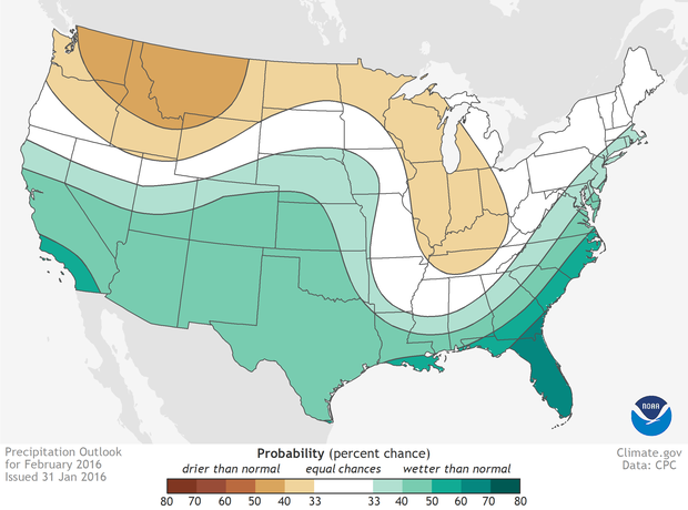
NOAA’s precipitation outlook for this February predicted well above average amounts of rain for Southern California, and ample precipitation for most of the rest of the state. Instead, California got almost nothing. Los Angeles, which averages 3.8 inches of rain for February, got less than one inch; since October only about five inches of rain has fallen on the city. The San Francisco Bay area has also suffered, but an “atmospheric river” will yield some major rainfall this week. Snowpack in many areas of the Sierras, Cascades, and Rockies, which will melt and offer relief to the valleys below, is still well below average; Kapnick said many locations are at or close to all-time-low snowpack.
On supporting science journalism
If you're enjoying this article, consider supporting our award-winning journalism by subscribing. By purchasing a subscription you are helping to ensure the future of impactful stories about the discoveries and ideas shaping our world today.

El Niño doesn't always mean wet years in California. In some cases, El Niño has been associated with some of the driest years on record.
Credit: NOAA
According to Martin Hoerling, of NOAA’s physical sciences division who also spoke during the briefing, those differing flavors mean it can be hard to say in advance exactly what the impacts of a given El Niño will be in a specific place. In fact, looking throughout the historical record specifically for California, certain El Niño years—1982 through 1983 and 1997 through 1998, for example—were associated with extremely wet years, but others such as 1923 through 1924 and 1976 through 1977 were actually associated with some of the driest years on record in California.
Part of the problem with prediction is that we actually don’t have much data on prior El Niño impacts. There have been more than 20 events since record keeping began more than 100 years ago, but Hoerling said only two events qualify as “very strong El Niños.” The current event also qualifies (and will likely go down as one of the three strongest on record), but that means using the similar events in the past to predict the future is problematic. Two data points are not nearly enough to try and tease out detailed trends.
Hoerling said his research team has run modeling scenarios hundreds of times for very strong El Niños to try and predict the next few months of impacts. “One thing that stands out is that even with exactly the same El Niño expression, the same flavor, there is a diversity of outcomes,” he said. “That diversity simply speaks to the chaotic aspect of the way weather can vary unrelated to what the ocean is doing. There can be extended periods where the atmosphere couldn’t care less about what the ocean is doing.”
The latest predictions, though, still offer optimism to a thirsty region. NOAA’s three-month outlook for the March, April and May period offers a 33- to 50-percent chance for above-normal precipitation across California, Arizona, and New Mexico.
Outside of the Southwest U.S., the impacts of El Niño can vary just as widely—and wildly. The phenomenon’s current iteration has been implicated in extreme weather around the world, from a failure of spring rains in Ethiopia and Sudan that affected crop growth to enormous flooding events in Paraguay and surrounding countries in recent months that has led to mass evacuations. El Niño is also responsible for extending the longest coral bleaching event ever observed.
Nuisance flooding, meaning flood events related to tides rather than major storms, is also dramatically more common with this El Niño than in previous years thanks to climate change. NOAA tidal gauges have shown a 300- to 900-percent increase in nuisance tidal flooding since 1960 as sea levels have risen, and 2015-2016 flooding has already surpassed El Niño-related projections and broken a number of records around the U.S, from San Diego to Wilmington, North Carolina.
As for drought relief in California, the jury is still out on exactly how much benefit this El Niño will end up providing. “We see a very checkered history of what California experiences during El Niño,” Hoerling said. “One of our science challenges is to make sense of the record.”