As surface water has dwindled during California’s epic drought, desperate farmers and municipalities have staged a run on other sources: the state’s vast underground hydrological savings banks, such as aquifers beneath the Sacramento and San Joaquin river basins. Before the great dry spell, about 40 percent of California’s water supply came from these underground reservoirs. But by 2015, the percentage had jumped to 75.
Refilling these vaults won’t be easy because they’ve been drained so heavily. In California’s Central Valley, groundwater levels have plummeted up to 100 feet lower than previously recorded. Restocking is also hard because an aquifer "is more like a colander than a bank,” says Andrew Fisher, a hydrogeologist at the University of California, Santa Cruz. As some water trickles in, other water leaks out—into streams, lakes, and wetlands.
But an underground refill is crucial, so Fisher has developed a scheme to increase the water going in. The idea is to grab stormwater that typically rushes off into waterways and out to the Pacific Ocean. Fisher plans to capture some of that water in special ponds and wells designed to allow water to trickle through the soil down to the aquifers below. Particles and microbes in the soil should help cleanse the water of contaminants that it picked up, such as nitrogen pollution from agricultural runoff.
On supporting science journalism
If you're enjoying this article, consider supporting our award-winning journalism by subscribing. By purchasing a subscription you are helping to ensure the future of impactful stories about the discoveries and ideas shaping our world today.
A pilot project is already underway in the state’s Central Coast, and on March 16, a local water management agency will decide whether to approve three additional restoration projects.
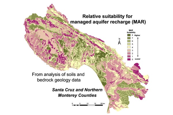
To find the best locations for recapture projects, Fisher and his colleagues have taken a two-pronged approach in California’s Monterey and Santa Cruz counties. They’ve used geographic information system mapping to analyze such factors as the slope of the land, the size of possible catchment areas, and the conditions of aquifers below. And they’ve used computer modeling to identify areas where there might be sufficient stormwater runoff.
The ultimate goal is not only to help farmers in need of irrigation water but also to push back against saltwater intrusion from the sea—a looming problem threatening both municipal and agricultural water supplies—by boosting fresh water in the underground aquifers on land. The approach could also aid plants and animals living along streams and in wetlands, which depend on water from the aquifers during dry summers.
“We are trying to return the hydrological system to what it once was like, so it can work better," Fisher says.
Changes in storm patterns over California make this a timely move. Rain clouds are dumping more intense bursts of water, thanks to climate change. A study by Fisher and his colleagues shows that while total precipitation in the San Francisco Bay area hasn’t changed much in 120 years, the rain is coming in shorter but heavier bouts.
This local trend is mirrored globally, says Kevin Trenberth, a climate scientist with the National Center for Atmospheric Research in Boulder, Colorado. “The dries are getting drier, and the wet is getting wetter,” he says. “And with continuing climate change, this will only get worse.”
Unfortunately, more intense rainfall doesn’t translate automatically into more water for aquifers. “With a greater fraction of the precipitation falling in shorter, more intense storms, you tend to have less of an opportunity for water to percolate into the ground,” Fisher says. Instead, it runs off fast into rivers and out to sea.
Trenberth, like Fisher, sees a lost opportunity here. Even as mining of groundwater continues, “there is no systematic attempt to get some of the excess stormwater into the ground,” he says.
That's what Fisher is trying to change, starting with his Central Coast pilot project in an area called the Pajaro Valley. This region, with the city of Watsonville at its heart, is “ground zero for high value agricultural crops, such as organic berries, fancy vegetables, and salad crops,” Fisher says. At the same time, “it is completely dependent on local groundwater." The high value of the Parajo Valley’s agriculture, combined with the unsustainable groundwater withdrawals, make the area a great place to start, Fisher says.
During the past four years, his team has had an approximately 180-acre field site operating on land in the valley that is in part a working ranch. The researchers have built a two-acre infiltration basin—basically, a modified pond—into which a simple ditch directs stormwater. All that’s needed is gravity. “It involves some engineering, but it is pretty low tech," Fisher says. The focus is on “keeping it simple.”
“We’re working on ways of helping to get more water into the basin, figuring out ways it can be managed so the system doesn’t clog, for example, and also to improve water quality,” he says.
There are sites where a pond may not be appropriate, in a highly developed area, for example, or a place where standing water could pose a public health concern. For those sites, Fisher’s team is working on an alternative: a variation on dry wells that have been widely used in to handle stormwater runoff in places like parking lots.
With this system, stormwater enters through an intake into a buried chamber where debris settles out and the water is filtered. It then goes into a second chamber, which can extend 100 feet or more into the ground. From here, it is released. “The idea is to put the water into the top of the aquifer material, but above the actual water table, so it can be cleaned a bit as it percolates downward into the aquifer.” To help filter contaminants, the researchers have been experimenting with different materials, such as wood chips and charcoal, which can be used at the bottom of infiltration ponds and inside dry wells.
If the board of the Pajaro Valley Water Management Agency approves his expansion plan in their mid-March vote, Fisher will try to use the project to show these methods can cut water costs for landowners. The three additional areas will have water usage meters that run backwards as well as forwards. In other words, a meter would not only measure the groundwater spent by a farmer for irrigation, but it would also spin back to account for the water added back from an infiltration pond on the property. This is akin to the net metering used for photovoltaic systems.
“Landowners who put these systems in would have water costs offset by this approach,” Fisher says. “This has never been done with groundwater.”
Within the Pajaro Valley, his longer-term goal is to get eight to ten systems installed that would infiltrate about 1,000 acre-feet of extra water into the aquifer below in total. An acre-foot is about 326,000 gallons, and it’s enough to cover an acre of ground to a depth of a foot. On average, California households use between one-half and one acre-foot of water annually for indoor and outdoor use (but consumption in some areas is much higher).
Overall, Fisher believes these systems can boost groundwater recharge in the area by 10 percent. “For this basin, that would be a significant achievement,” Fisher says.
Still, that relatively low number also highlights the challenge of using groundwater more sustainably. “We need a portfolio of solutions,” Fisher says—including improved conservation efforts. “No one solution will get us to 100 percent. We have to do a little bit here and a little bit there."