Cities around the world are getting hotter as the planet warms, and the consequences can be deadly. Researchers have linked heat waves like the one that hit Russia in 2010—killing 55,000 people—to climate change. And even without global warming, cities tend to bake when the weather gets warm. Surfaces such as asphalt roads and concrete buildings absorb and then radiate a lot of solar energy, which can leave urban areas 6 to 8 degrees Celsius warmer than rural regions.
Although some people can just crank up the air-conditioning amid increasingly brutal heat, many cannot. Urban decision makers need to know where to focus resources as they plan their adaptation strategies, potentially as a matter of life and death. But how can they pinpoint the most vulnerable populations? In a recent study researchers answered this question for Philadelphia by mapping the places where residents are most at risk.
For their paper, published in Applied Geography, researchers at the Earth Institute at Columbia University and Battelle Memorial Institute studied air temperature data from weather stations, land surface temperatures measured by satellites and socioeconomic data. First they used the weather station data to determine how temperatures in Philadelphia’s urban and surrounding rural areas had changed over time. They found the number of “extreme heat event” days in the city had risen threefold from about four in 1980 to nearly 12 in 2013. The nearby rural areas experienced no change over the same period, remaining at five extreme heat event days per year. The authors defined a heat event as three or more successive days in which the 24-hour daily mean temperature rose above a certain historical average high for July and August—in Philadelphia’s case, 27 degrees Celsius. “That means that it is staying hot all day and all night, with no relief for three or more days,” explains Stephanie Weber, a principal research scientist at Battelle and one of the study co-authors. “It’s not the hottest temperature, but something that when it is sustained and without relief during the night [and] early morning can pose serious health risks.”
On supporting science journalism
If you're enjoying this article, consider supporting our award-winning journalism by subscribing. By purchasing a subscription you are helping to ensure the future of impactful stories about the discoveries and ideas shaping our world today.
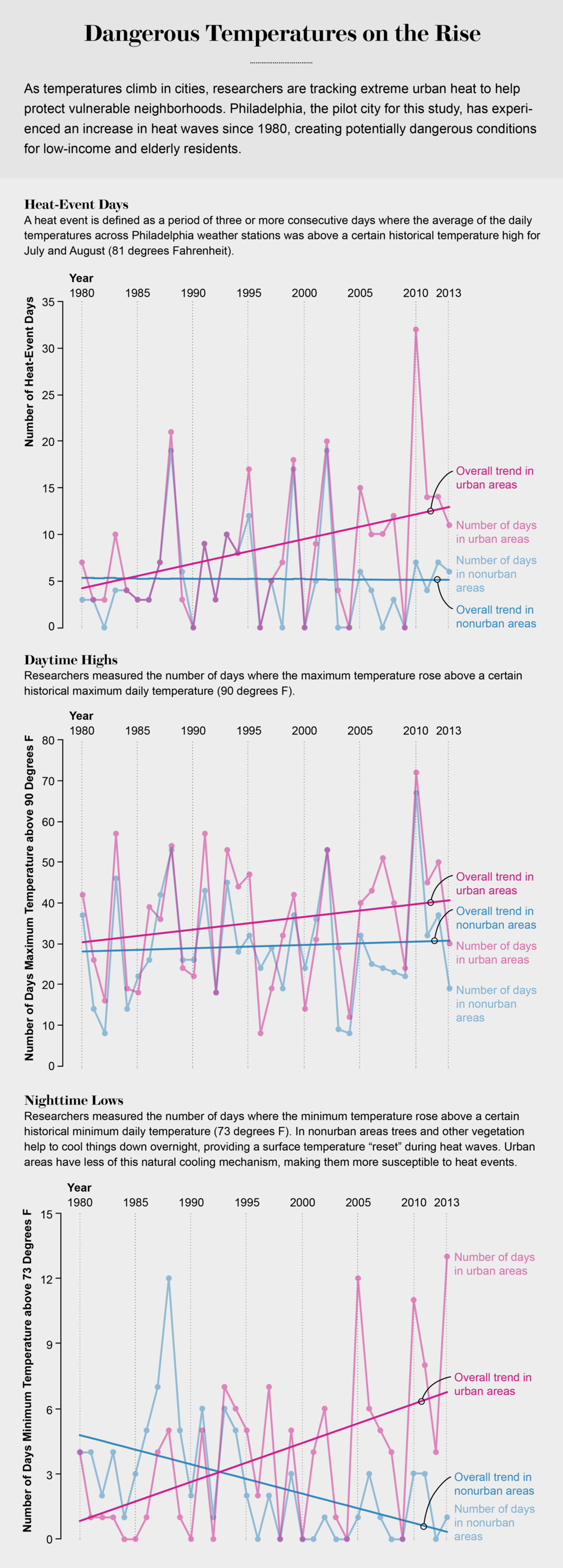
Credit: Amanda Montañez; Source: “Policy-Relevant Indicators for Mapping the Vulnerability of Urban Populations to Extreme Heat Events: A Case Study of Philadelphia,” by Stephanie Weber et al., in Applied Geography, Vol. 63; July 2015
The researchers also found the urban areas experienced a huge increase in the number of “hotter than normal” nights—which actually decreased in the rural areas over the same period. This is significant for city dwellers’ health, says Alex de Sherbinin, one of the study authors and associate director of science applications at the Earth Institute’s Center for International Earth Science Information Network. “What’s perhaps the most important for heat stress in these urban environments is what goes on at night,” he explains. “It’s the cooling at night that’s important for the elderly and others who are not living in air-conditioned circumstances.” De Sherbinin notes the research did not tease apart how much these trends were caused by the urban heating effect versus climate change.
De Sherbinin and his team—Weber, Natasha Sadoff and Erica Zell—then mapped where Philadelphia’s most heat-sensitive populations live. They looked at factors including income, education level and households of people over age 65 who live alone. They combined this information with the land surface temperatures measured by satellite and found that more than half a million people—about 10 percent of the population—inhabit neighborhoods that are most vulnerable to heat event health impacts.

Experts who were not involved in the project note it did not consider some factors that might better identify the most vulnerable populations. “I would have encouraged someone doing this type of study to look for indicators of social cohesion and connections—for institutions like churches,” whose members, for example, might have social contacts who can shelter them in emergencies, explains Jason Corburn, who directs the Institute of Urban and Regional Development and the Center for Global Healthy Cities at the University of California, Berkeley. “In a heat event those factors matter for vulnerability. They also matter for people getting information about whether a heat event is coming.” Corburn also thinks the researchers should have included city-level health data in their assessment.

Philadelphia social sensitivity to heat by census block group, with 0.0 - 1.0 as the least sensitive.Credit: Battelle Memorial Institute
Another expert, Brian Stone, director of the Urban Climate Lab at Georgia Institute of Technology, thinks satellite land surface temperatures are not a reliable measure for the heat people experience—these measurements gauge the temperature at the sidewalk level, rather than a meter or two above it. The difference can be significant. Sherbinin, however, believes his team’s method is reasonable. “Using land surface temperature [data] to define the…most heat-exposed neighborhoods I believe is completely justified, since this is a relative measure of the most heat-impacted neighborhoods,” he wrote in an e-mail. Matei Georgescu, associate director of the School of Geographical Sciences and Urban Planning at Arizona State University, explains that even though satellite-measured land surface temperatures may not be an ideal indicator, this limited data can still help answer research questions. “I think the work is a useful step in trying to understand where and how cities should be managing their particular neighborhoods, in terms of who is exposed and what the sensitivities are,” he says.
De Sherbinin and his team also worked with local officials, academics and othersfor their study, and presented their results to a Philadelphia advisory group at the end. Equipped with this sort of information, city plannerscan better design cities by creating green spaces or building “cooling centers”—places where those lacking air conditioners can shelter during extreme weather—in the most heat-vulnerable neighborhoods. They could also offer better social services to the most sensitive populations. In the future de Sherbinin hopes to apply this approach to other parts of the U.S. and beyond, in cities such as Shanghai and Mumbai.