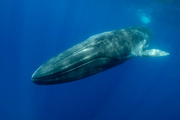
Scientists investigating a seismic fault off the U.S. West Coast have an unlikely new ally in their quest to create images of the Earth’s crust deep beneath the ocean: Fin whales.
Fin whales (Balaenoptera physalus) are 20- to 25-meter-long (60 to 85 foot) behemoths whose songs can be heard up to 1,000 kilometers (600 miles) away, booming through the seas as loudly as a ship’s engine does. New research, published in February in Science, finds these calls’ sound waves can help create images of the seafloor subsurface down to 2.5 kilometers (1.6 miles).
Seafloor imaging, which is important for studying things like earthquake mechanics and carbon storage capacity, typically uses large air guns that send blasts of sound downward. The sound waves penetrate the crust and bounce back to instruments on the seafloor, carrying information about the structures they travel through. But such surveys are expensive, and the guns’ concussive noise may disturb marine mammals that use sound to communicate.
On supporting science journalism
If you're enjoying this article, consider supporting our award-winning journalism by subscribing. By purchasing a subscription you are helping to ensure the future of impactful stories about the discoveries and ideas shaping our world today.
“It’s actually quite cool to have another source of information,” says study co-author Václav Kuna, a seismologist at the Institute of Geophysics of the Czech Academy of Sciences.
Kuna, then at Oregon State University, was studying earthquakes on the Blanco transform fault off the Oregon Coast in 2012 and 2013 when he noticed strange readings on the seafloor seismic instruments. The readings turned out to match the frequencies of fin whale calls.
Whale vocalizations often appear in such instruments’ records, says Emily Roland, a marine seismologist at the University of Washington who was not involved in the study. Seismologists usually see these signals as a nuisance. Kuna, however, noticed that some signals appeared only on the seafloor instruments’ seismometers, which measure vibrations; their audio microphones did not pick up any corresponding sounds. This meant the signals were not coming directly from the whales, but were echoes bouncing back from within the crust.
To use such signals for imaging, Kuna had to pinpoint the whales’ locations. This was possible because each whale call made two sets of waves: one that traveled directly to the seismic station on the ocean floor, and another that bounced between the ocean floor and surface before hitting the same station. By comparing the arrival times of these two waves, Kuna could calculate the whales’ approximate locations.
Fin whales sing in loud, one-second pulses. This pattern is good for seismic imaging because pulses are easier to analyze than continuous noise, says the University of Washington’s William Wilcock, a marine geophysicist who was not involved in the study but has used seismic instruments to track whales. These whales are found almost everywhere except the ice-covered portions of the Arctic, he notes—so their calls “could potentially be used in a lot of regions.”
This technique does have limitations, Kuna says. Fin whale songs are limited in frequency, meaning the subsurface images are not as crisp as those made with air guns. Additionally, a relatively flat seafloor is needed to triangulate the whales’ positions and use their sounds for data analysis with just a single seismic station; multiple stations would be needed in sloping or mountainous regions, he adds.
Nevertheless, whale calls’ prevalence means they could provide new insight into old seismic datasets, Roland says. More imagery of the first 2.5 kilometers of ocean sediments and crust could be used in fields including climatology (to better estimate the amount of carbon storage available in the sediments), and seismology (to precisely pinpoint earthquake locations and determine how sediments and the crust interact at fault zones).
“If we use the whale songs at least as a complement to other sources of signals, they are free and they are always there,” Kuna says. “It’s a win-win.”
A version of this article with the title “Imaging Calls” was adapted for inclusion in the May 2021 issue of Scientific American.